
Community Profile
Population
Shepton Mallet falls within the area of Mendip District Council (MDC) emerging as a Unitary Authority in April 2023. The overall population size of the parish according to the 20112 census was 10,369, or 9.49% of the whole unitary authority, living in 4,377 dwellings. The population of MDC was recorded in the 2011 census1 was 109,279 representing a 5.2% increase since the 2001 census.
At the time of writing, 2021 census data is not available
|
Key Facts: (2011 Census) |
Shepton Mallet Neighbourhood Area |
| Area: | 924.26 hectares |
| Total Population: | 10,369 |
|
Population Density: |
11.22 |
| Households: | 4,377 |
Deprevation Levels
In terms of deprivation levels, the English Indices of Multiple Deprivation3 measure relative levels of deprivation in small areas called Lower Layer Super Output Areas (LSOAs). These are small areas of approximately 1500 households which, unlike local government wards are defined geographical areas broadly based on community boundaries and do not change over time. Shepton East is the most deprived ward of the district, lying just outside the 10% most deprived wards in the country.
Shepton Mallet is one of two towns in Mendip which has an issue with deprivation, despite the Mendip District having a relatively small proportion of its population living in an area amongst the top twenty percent nationally for income deprivation affecting older people and children. About 14% (2,800) of children in the Mendips live in poverty and life expectancy is 5.4yrs less in the most deprived areas compared to the least deprived areas. (Public Health England, Mendip district 2014).
MDC is ranked 217 out of the 354 English local authorities (where 1 is the most deprived) which makes it one of the 30% least deprived of local authorities in the country.
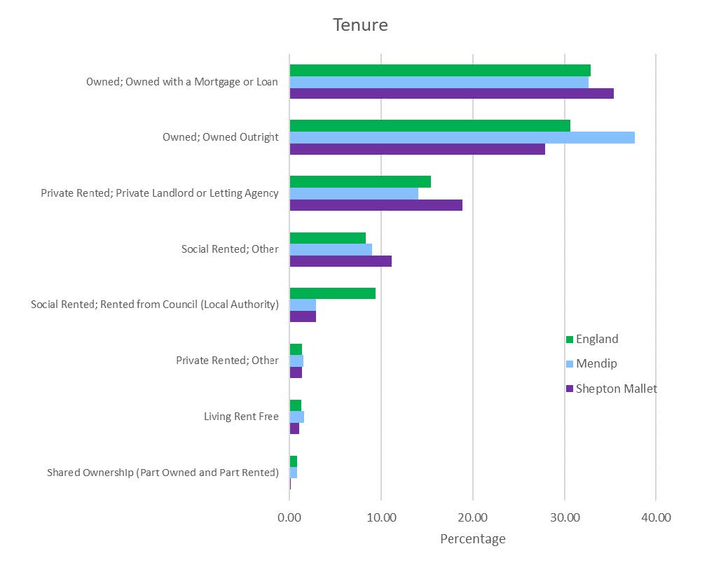
Housing Data
There were 4,377 households in Shepton Mallet at the time of the 2011 census (9.48% of the 46,157 households across the Mendip District). The neighbourhood area had 10,369 usual residents and covers an area of 924 hectares.
In Shepton Mallet Parish there were 930 detached dwellings representing 20.4% of all dwellings in the neighbourhood area. There were also 1572 semi-detached and 1268 terraced dwellings equating to 34.5% and 27.8% respectively. The percentages for Mendip District were: 31.3% detached; 31.4% semi-detached and 24.6% terraced. 10.6% of all households were one-person pensioner households significantly lower than the figure for MDC (13.8%). 29.1% of households in the neighbourhood area had dependent children, similar to 27.3% across MDC. There were 295 lone parent households (with dependent children) which equates to 6.7% of all households, marginally higher than the 6.1% figure for MDC.
Employment
At the time of the census, there were 7,716 residents 74.4%) who were available to work (aged between 16-74). Of these, 70.2% were in employment, higher than the figures for MDC (66.3%) and England (62%). 9.6% were self-employed against 14.2% across MDC. 3.3% of Shepton Mallet residents were unemployed compared to 2.9% across Mendip District and 4.4% across England.

Labour Force
Of those aged over 16 (5,514 residents), 21.09% of the population of Shepton Mallet Parish has a degree qualification or higher, lower than the 27.9% in the district, and lower than the 27.40% in England. The number with no formal qualifications at all stands at 1,947 people, or 23.17%, compared to 21.40% in the district and 22.50% across England as a whole.
Travel to Work
3.8% of residents worked from home compared to 6.4% at district level. The car is used as the main means of travel to work for 48.1% (MDC is 44.6%), while 1.1% use public transport (MDC is 3%) and 12.4% travel on foot (MDC is 9.4%).
