Transport in Shepton Mallet
In February 2021, a Transport Report was produced by HTP Consulting. This report was commissioned by the Neighbourhood Plan Steering Group to consider the issues which have been highlighted during the consultation process in relation to traffic and transport in Shepton Mallet.
Download a copy of the Transport Report
This report identifies a number of issues, some of which can be addressed through the Shepton Mallet Neighbourhood Plan, others have become community aspirations.
These issues have been captured in the Vision and Objectives and the following policies reflect this.
In addition to the issues identified for delivery through this Neighbourhood Plan, there are a wide range of subjects which the community wishes to see addressed. These are community aspirations and are included within Appendix Traffic Report, to be taken forward by the Town Council who are including them within their strategic Town Plan.
POLICY EIGHT: INGRESS & EGRESS FROM NEW DEVELOPMENT
OBJECTIVE 11
To ensure sufficient ingress and egress to and from any new developments to minimise detrimental effects of increases to vehicle usage
- Development proposals must demonstrate how they can be incorporated in a satisfactory way into the capacity of the local highway network.
- Development proposals which require new estate roads to be constructed should ensure these roads meet the standards required by Somerset County Council for their adoption.
- Development proposals which intend for estate roads to be adopted, will be strongly encouraged, particularly where drainage networks are routed underneath estate roads. This will be secured through the use of appropriate planning conditions.
- If development proposals do not provide an intention, through the use of a planning condition, to adopt estate roads, and drainage networks are proposed to be placed under these roads, then the proposals are expected to demonstrate that there are no other reasonable alternative routes or methods for the provision of satisfactory drainage.
Policy Eight: Reasoned Justification
99 Shepton Mallet has been allocated substantial development during the Plan period which will have a significant impact on the infrastructure needs of the community, in particular the traffic infrastructure.
99 Cannards Grave development to the south of the town is a major urban extension and high volumes of traffic are expected as a result
100 In addition, Policy Two of this Plan identifies land to the west of Cannards Grave for development which will add to this traffic.
101 Therefore, it is crucial that any applications coming forward contain a statement identifying the traffic impact on the wider community e.g. congestion and parking and it is reasonable to expect that proposals for mitigating the impact are put forward.
102 Proposals must also explain how there is safe access for vehicles and pedestrians which does not adversely affect the free movement of traffic in the vicinity.
103 A new estate road serving a new development can either be adopted by the highway authority, Somerset Council, or remain un-adopted, with its upkeep ultimately the responsibility lying with the property owners. For a road to be adopted, it must meet certain Somerset Council standards, as provided in the Somerset Highways information.
104 There has been growing concern about the number of un-adopted roads which require homeowners to pay an additional service charge for their upkeep and maintenance. This is not only for the road itself: the drainage systems that often run underneath the road also have to be similarly un-adopted. In an area of Somerset such as Shepton Mallet, where the risk of surface water flooding has been proven to be significant, it is particularly important that drainage solutions can be adopted by the drainage authority.
POLICY NINE: LOCAL MOVEMENT ROUTES
OBJECTIVE 12
To encourage walking and cycling by improving local transport links and public right of way routes within the neighbourhood area and to adjacent parishes, including green lanes to provide for safer travel and healthier lifestyles.
OBJECTIVE 13
Improve cycle routes in the town and connect to the Strawberry Line
OBJECTIVE 16
Provide adequate parking facilities are available for vehicles and cycles
i. New developments will be encouraged to create publicly accessible links from development sites to the wider footpath network/green spaces and, where possible, to public transport nodes in order to address gaps in the network and to improve existing provision.
ii. New developments will be encouraged to provide cycle paths into the centre of the town.
iii. New developments will be expected to provide pavements serving the new dwellings that are of sufficient width to accommodate at least two persons walking abreast and are suitably accessible for wheelchairs, prams and pushchairs.
iv. Developer contribution will be sought to deliver improvements to longer distance cycling routes including along the Strawberry Line.
v. Developer contribution will also be sought to create segregated routes and cycle parking facilities as follows: a. Route to the primary school at Cannards Grave from catchment areas such as Tadley Acres and Ridgeway estates including a crossing of the Cannards Grave Road
- Routes to Whitstone school from Tadley Acres and Ridgeway estates
- Cycle parking facilities: eg bike parking racks
Reasoned Justification for Policy Nine
105 There is little evidence of widespread cycling in and around Shepton Mallet due to a number of factors:
• Poor on route facilities.
• Hilliness of the area.
• Lack of tradition of cycling.
• Lack of good cycle parking facilities.
• Feels dangerous to cycle.
• As is the case in many historic English towns, the streets tend to be narrow, making it difficult for cars to overtake cycles safely.
• External to the town the roads are narrow, bendy, and fast.
106 The town is of a scale that should make movement by such modes a logical choice. Equally though, the ability to access the open countryside away from the town is important. As shown in Fig. Need to source footpath & cycleways map there is a significant network of footpaths and, to a lesser extent, cycle paths serving the neighbourhood area.
107 A number of these paths utilise disused railway lines or Roman roads, providing scenic routes which encourage tourism to the town.
108 The East Mendip Way runs through the town from Uphill near Weston Super Mare through to Frome and a section of the Fosse Way which runs from Exeter to Leicester.
109 Currently, only 1% of people commute to work by bicycle in the UK and flows for cycles are low around Shepton Mallet. For example, the A371 west of the town has just 0.2% cycles. Data from the most recent census found that 16.4% of households did not own a car or van, suggesting that many households in Shepton Mallet will be reliant on other forms of transport which would include cycling
110 Cycling and facilities for cyclists, which needs to be accessible to all users and are best considered in three categories:
• Routes to school, which must be segregated from traffic and suitable for children.
• Commuter cyclists who want direct routes and can mix with traffic.
• Recreational cycling which is best segregated and mostly in rural areas.
111 Recent DfT Cycle Infrastructure guidance (LTN1/20) places great emphasis on encouraging cycling. It says that all routes should be segregated between both traffic and pedestrians. This places great challenges to retrofit facilities, but it is something that all highway authorities are grappling with.
112 Essentially, it is now a requirement to plan for more cycling as it makes us heathier, reducing reliance on private vehicles, reducing carbon and can be just as fast for trips less than 5kms. Policy Ten is intended to encourage a shift towards cycling in and around Shepton Mallet.
113 It is important that new development is designed carefully to ensure that new properties have good access, both to the village and to the open countryside, by non-car modes. Whilst cycle routes are designated through the village, these do not provide dedicated space for cyclists, so do not, of themselves, encourage an increase in cycle usage.

Cycle Routes through the town.
Community Aspiration: Better Traffic Management
Seek developer contribution through 106 or CIL agreements to improve traffic management within the town centre
116 During the extensive survey work carried out to create this plan, it became apparent that some feedback comments from the community included issues or proposals that were not suitable to be included as policies in a Neighbourhood Plan as they did not relate to land use.
117 However, they are issues of importance to the community and are reflected in the Vision and Objectives. It is therefore felt important to incorporate them within the Plan to draw attention to them for consideration for spending priorities.
118 There is a comprehensive list of priorities for the Town Council to progress included as Appendix Community Aspirations, however, where an objective has been included, the aspiration is included in the body of the plan.
Assessment of the Reasoning for Community Aspiration One
1) The most recent census data (2011) for Shepton Mallet found that 83.6% of households had at least one car (or van) – with the remaining 16.4% of households not owning a car (or van)
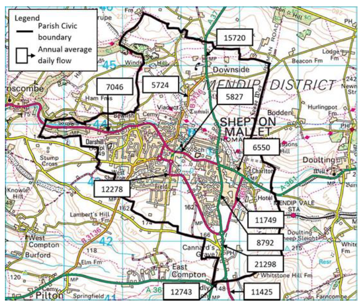
2) Daily Annual Average Traffic (AADT) flows on the main roads in and around the town are shown on Fig TP14A below. The busiest local road is the A37 to the east, south of the A371 junction with flows of a 21,300 vpd. The A371 in the town has flows of about 12,300 vpd just south of the memorial junction. The A361 near the High Street has a flow of about 5,800 vpd.
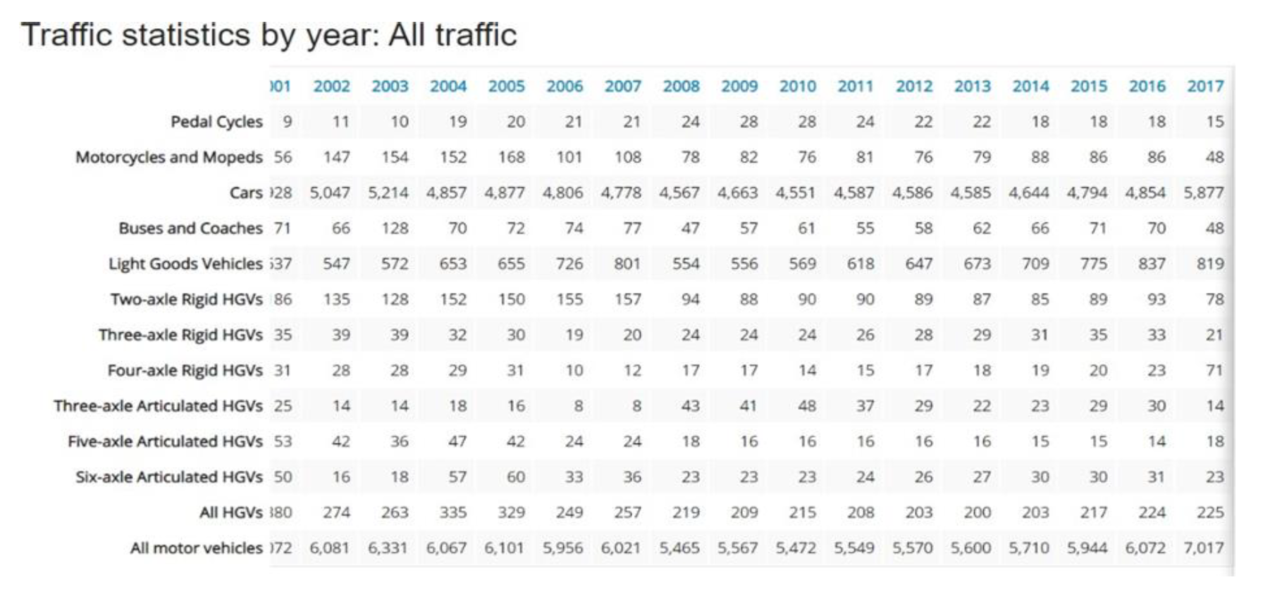
3) The A31 traffic flows are summarised in table TP14B below which shows a typical growth in traffic from 6,100 vehicles per day to 7,000 vpd between 2002 and 2017. This represents a growth of 15% over 15 years.
4) These flows are not untypical of small towns. However, the A371 has a high volume of flow and much of it is through traffic which is impacting environmentally on adjacent land uses. Through traffic is also more likely to be travelling at speed with little interest in the town. However, some of this traffic is composed of visitors and tourists who provide an opportunity to be attracted to slow, stop and spend in the town.
 TP14B Traffic Growth 2001-2017
5) Traffic routes are generally two-way single carriageway roads. Management of traffic takes place in three main ways.
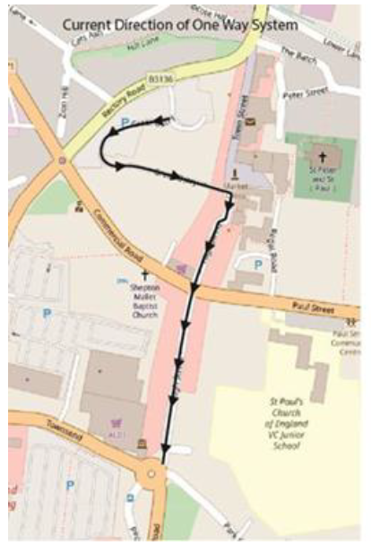
6) The one-way system as shown on Figure. Currently this is southbound only between Rectory Road, the High Street and Townsend Road.
7) Restricted vehicle types, notably a 7.5t ban on the A361 between the A371 and A37.
8) Restrictions to traffic speeds, with much of the town at 30mph and parts of the town centre as 20mph.
9) There would be advantages in reversing the direction of the one- way system as shown on Fig xxx below. The advantages are:
- More drivers potentially using the northern town centre area would drive through on their way to park and so help to increase trade to that area.
- Visitors / tourists would more easily find the High Street and especially the upper High Street area. Nearly all visitors will travel through the Memorial junction, so if a sign from here directs to the town centre, then it would be a much simpler and a more pleasant access route than the existing off Rectory Road and its car parks. The northbound route would also allow drivers to pass some free 30-minute maximum stay parking spaces which would encourage them to stop and browse.
10) The Great Ostry access changes need detailed investigation to clarify the options and this Aspiration is intended to place Developer Contribution into both a consideration and delivery of these options
11) The A361/High St junction requires redesigning anyway, due to the accident record and this aspiration will provide an opportunity to do so.
|
|
|
 |
 |
|
|
Fig: annual average traffic flow |
Fig: current direction of one-way |
Fig: proposed direction of one-way |
POLICY TEN: PUBLIC TRANSPORT
OBJECTIVE 15
Help reduce carbon emissions by encouraging the use of public transport with improved services and facilities
i. Where appropriate, developer contributions will be used to improve the levels of public transport patronage. These contributions will be used to provide improved information about timescales (such as real time passenger information) and routes
ii. In particular, the MasterPlan for the strategic sites and the site allocated through this Plan are expected to identify appropriate travel plans for linking to key services
Reasoned Justification for Policy Ten
114 Shepton Mallet bus services are covered by three main bus operators First Group, Southwest Coaches and Frome Bus. Mendip Community Transport provide subsidised dial a ride and pre- bookable hire services for older and more vulnerable travelers locally. There are some services that travel further afield such at National Express, Berry Coaches and Superfast 3.
115 Use of public transport provides access to larger towns and cities such Bath, Bristol and Weston-Super Mare. Some routes are indirect and require changes to a second service along the route.

116 Table below gives a summary of the bus services to and from Shepton Mallet revealing a mixed picture of services to local service centres of Wells, Frome, Castle Cary and Glastonbury with a direct route to Bath taking an hour.
117 These are essential services for the town and need to be retained for access to school, services, employment, and tourism.
118 It is therefore important that all efforts are made to support the existing bus services but also to ensure that this does not result in increased fares. This can be effectively achieved by increasing patronage through improvements to information, such as real-time passenger information at bus stops.
119 Developer contributions from development can be used to contribute towards addressing these issues either through a 106 agreement or through contributions secured through CIL

The bus routes and times change frequently. This table was correct at the time of writing: March 2023

